Geoblog.pl  ceta Podróże Kolumbia 2015 Wrocław => Berlin Tegel / Czy brać namiot?! / Opis gór i parków w Kolumbii: Ciudad Perdida, Tayrona, Nevados National Park, Sierra Nevada del Cocuy
ceta Podróże Kolumbia 2015 Wrocław => Berlin Tegel / Czy brać namiot?! / Opis gór i parków w Kolumbii: Ciudad Perdida, Tayrona, Nevados National Park, Sierra Nevada del Cocuy 
2015
20
mar
Wrocław => Berlin Tegel / Czy brać namiot?! / Opis gór i parków w Kolumbii: Ciudad Perdida, Tayrona, Nevados National Park, Sierra Nevada del Cocuy
Niemcy, Berlin
Przejechano 285 km
Czy brać namiot?!
Oto jest pytanie ....
Czytając od pół roku czasem jakiś blog czy opisy wypraw sporo ludzi taszczy się do Ameryki Południowej z namiotem, śpiworem, jedzeniem i cała resztą...
np Kolumbia oferuje mnóstwo parków narodowych - od gór poprzez dżungle , a nawet wulkany czy campingi na dziko wśród pól kawy...
Po wielu namysłach doszliśmy do wniosku, że też to wszystko bierzemy ;) kuchenkę etc i jednak jedziemy w góry :)
Kształtuje się plan zobaczenia parku narodowego Sierra Nevada del Cocuy
/ Parque Natural Sierra Nevada del Cocuy /
chyba będziemy tam 3-5 dni
Z wiki:
"Sierra Nevada del Cocuy:
The Park area contains several high peaks covered with snow:
Pan de Azúcar (5120m), Diamante (4800 m), el Púlpito del Diablo (5100 m), Toti (4800 m), Portales (4800 m), Cóncavo (5200 m), Concavito (5100 m), San Pablines South (5180 m) and North (5200 m), Ritacuba Blanco (5330 m), Picacho (5030 m), Puntiagudo (5200 m), Ritacuba Negro (5300 m), el Castillo (5100 m), peak without name (5000 m), Sirara (5200 m)."
----------------------------------------------------------------
OPISY parków znalezione w internecie:
Znaleźć coś w internecie o poruszaniu się po tych parkach to nie lada sztuka i w ogóle o drogach, szlakach, mapach jest dość trudno coś wygooglować ...
Dobra strona o parkach w Kolumbii
parki strona
Poniżej ogólna informacja dla wspinaczy z wyżej wymienionej strony:
Mountaineering:
"Major visited mountains in Colombia are, from north to south, the Sierra Nevada (Lost City), the Sierra Nevada del Cocuy, the Parque de los Nevados and Puracé and Galeras volcano.
Due to the internal armed conflict in Colombia for more than 40 years, acute and degenerated in recent years by drug interests. For this reason, many mountain areas are closed for the mountaineer or a tourist, or require prior consultation before embarking on a trip. There are currently inaccessible the Sierra Nevada de Santa Marta (with the exception of the coastal zone and Lost City), many moors of central and eastern cordillera and the Nevado del Huila. (In the description of each site will discuss the security situation)."
Rock Climbing
"Outside of the snow peaks and paramos, sport climbing have dveloped in Colombia in several places, with a very high technical level.
The most popular sites are:
- Cundinamarca: Suesca, La Calera and Machetá. Difficulties between 4 and 5.13.
- Santander: the Mesa de los Santos (near Bucaramanga)
- Antioquia: The Penol.
PARKI:
park: Sierra Nevada of Santa Marta - a w nim Lost City czyli Ciudad Perdida
"The Sierra Nevada de Santa Marta is the highest coastal mountain in the world, including the Caribbean and the eternal snows, geography encompasses all thermal, where all kinds of unique wildlife in the world.
It is also a haven for the latest ethnic descendants of the Tairona Indians, as the Kogi, the Arsarios and Arwacos. There live about 30,000 natives of these ethnic groups, their survival threatened by transculturation and violence. The Sierra Nevada is currently affected by deforestation by settlers, illicit coca and marijuana and the presence of guerrilla and paramilitary groups.
Due to this problem, today can be recommended only tourist-type visits Pueblito (Tayrona National Park) or the Lost City. For other places is essential prior consultation on the state of (dis) order, request permission from Indian authorities (in Valledupar, Santa Marta Nabusimake or, as appropriate) and carefully prepare the trip."
Czyli zwiedzanie tego parku poleca się tylko i wyłącznie z biurem i przewodnikiem...
Zazwyczaj z tego co wyczytałam wszystkie grupy prowadzone są w jedno miejsce: starożytne miasto , Lost City , czyli Ciudad Perdida - tam i powrót odbywa się to samą drogą , treking trwa 5 dni , i kosztuje prawie 1000pln od osoby ...
Nas nie zachęciło ... szczerze nawet ze zdjęć, grupy duże, dżungla dżungla dżungla, moskity!
park: PNN Tayrona
oficjalna strona parku
turystyczny, bezpieczny park z pięknymi plażami, podobno drogi , ale ze swoim namiotem taniej ;)
Uwaga! to bardzo popularne miejsce!
park: Nevados National Park - wulkany w tym wulkan Nevado del Tolima 5,276m
"Los Nevados Park can not compete with the Cocuy about the snow and rock climbing (with the exception of the Nevado del Tolima, the ibaguerenos say), but they do offer beautiful scenery and the chance to meet, touch and smell landscapes with active volcanism . In addition, the park is home to several beautiful lakes, including Lake Otún, the Laguna Verde and Laguna del Encanto.
A great advantage of the Park is its central location and easy access by air and by land, making possible a summit of 5,000 in 3-4 days, which in the snowy mountains of the country other is not possible."
Jak już ma się wybierać to podobno Cocuy jest lepszy ;)
Ale z kolei ten park jest łatwiej dostępny.
park: PNN Cocuy / Sierra Nevada del Cocuy
Jedyna sensowna strona to ta
Cocuy nevados
niestety po hiszpańsku są te informacje tylko dostępne..
Większość informacji dostałam przez maila od ludzi z forum Lonly Planet lub biur podroży po Kolumbii.
Na dzień dzisiejszy trasa Circuit jest zamknięta... ale niektórzy robią ją i tak nielegalnie...
Oto oficjalne info:
"It is possible to do some treks at PNN Cocuy - Guican, at the moment the Circuit trek is closed because the U'wa indians revoked the access on their reserved land."
Niby zaś to samo - góry są święte i nie można po nich chodzić ...
"The trail known as "RETURN TO THE SIERRA" is closed for determination of the indigenous community UWA."
"By decision of the U'wa people, the area of ??overlap with the indigenous territory (guard) is closed for ecotourism. Therefore it is not allowed to travel to the Eastern side of the Sierra Nevada."
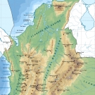
Strona oficjalna parku
Suuuuuper mapa która podał mi jeden Holender przez maila
MAPA
Info z forum LP:
"El Pulpito Diablo and La Laguna are pretty much the only day hikes from Cabina Sisuma. Both are fantastic though and offer totally different experiences. I recommend spending a day (hiking to La Laguna, or just hiking around the other nearby lagoons) to get acclimated before tackling El Pulpito."
-----------------------------
My spróbujemy najpierw Cocuy potem Tayrona ;)
Pozdrawiam
Katarzyna Cetkowska


Oto jest pytanie ....
Czytając od pół roku czasem jakiś blog czy opisy wypraw sporo ludzi taszczy się do Ameryki Południowej z namiotem, śpiworem, jedzeniem i cała resztą...
np Kolumbia oferuje mnóstwo parków narodowych - od gór poprzez dżungle , a nawet wulkany czy campingi na dziko wśród pól kawy...
Po wielu namysłach doszliśmy do wniosku, że też to wszystko bierzemy ;) kuchenkę etc i jednak jedziemy w góry :)
Kształtuje się plan zobaczenia parku narodowego Sierra Nevada del Cocuy
/ Parque Natural Sierra Nevada del Cocuy /
chyba będziemy tam 3-5 dni
Z wiki:
"Sierra Nevada del Cocuy:
The Park area contains several high peaks covered with snow:
Pan de Azúcar (5120m), Diamante (4800 m), el Púlpito del Diablo (5100 m), Toti (4800 m), Portales (4800 m), Cóncavo (5200 m), Concavito (5100 m), San Pablines South (5180 m) and North (5200 m), Ritacuba Blanco (5330 m), Picacho (5030 m), Puntiagudo (5200 m), Ritacuba Negro (5300 m), el Castillo (5100 m), peak without name (5000 m), Sirara (5200 m)."
----------------------------------------------------------------
OPISY parków znalezione w internecie:
Znaleźć coś w internecie o poruszaniu się po tych parkach to nie lada sztuka i w ogóle o drogach, szlakach, mapach jest dość trudno coś wygooglować ...
Dobra strona o parkach w Kolumbii
parki strona
Poniżej ogólna informacja dla wspinaczy z wyżej wymienionej strony:
Mountaineering:
"Major visited mountains in Colombia are, from north to south, the Sierra Nevada (Lost City), the Sierra Nevada del Cocuy, the Parque de los Nevados and Puracé and Galeras volcano.
Due to the internal armed conflict in Colombia for more than 40 years, acute and degenerated in recent years by drug interests. For this reason, many mountain areas are closed for the mountaineer or a tourist, or require prior consultation before embarking on a trip. There are currently inaccessible the Sierra Nevada de Santa Marta (with the exception of the coastal zone and Lost City), many moors of central and eastern cordillera and the Nevado del Huila. (In the description of each site will discuss the security situation)."
Rock Climbing
"Outside of the snow peaks and paramos, sport climbing have dveloped in Colombia in several places, with a very high technical level.
The most popular sites are:
- Cundinamarca: Suesca, La Calera and Machetá. Difficulties between 4 and 5.13.
- Santander: the Mesa de los Santos (near Bucaramanga)
- Antioquia: The Penol.
PARKI:
park: Sierra Nevada of Santa Marta - a w nim Lost City czyli Ciudad Perdida
"The Sierra Nevada de Santa Marta is the highest coastal mountain in the world, including the Caribbean and the eternal snows, geography encompasses all thermal, where all kinds of unique wildlife in the world.
It is also a haven for the latest ethnic descendants of the Tairona Indians, as the Kogi, the Arsarios and Arwacos. There live about 30,000 natives of these ethnic groups, their survival threatened by transculturation and violence. The Sierra Nevada is currently affected by deforestation by settlers, illicit coca and marijuana and the presence of guerrilla and paramilitary groups.
Due to this problem, today can be recommended only tourist-type visits Pueblito (Tayrona National Park) or the Lost City. For other places is essential prior consultation on the state of (dis) order, request permission from Indian authorities (in Valledupar, Santa Marta Nabusimake or, as appropriate) and carefully prepare the trip."
Czyli zwiedzanie tego parku poleca się tylko i wyłącznie z biurem i przewodnikiem...
Zazwyczaj z tego co wyczytałam wszystkie grupy prowadzone są w jedno miejsce: starożytne miasto , Lost City , czyli Ciudad Perdida - tam i powrót odbywa się to samą drogą , treking trwa 5 dni , i kosztuje prawie 1000pln od osoby ...
Nas nie zachęciło ... szczerze nawet ze zdjęć, grupy duże, dżungla dżungla dżungla, moskity!
park: PNN Tayrona
oficjalna strona parku
turystyczny, bezpieczny park z pięknymi plażami, podobno drogi , ale ze swoim namiotem taniej ;)
Uwaga! to bardzo popularne miejsce!
park: Nevados National Park - wulkany w tym wulkan Nevado del Tolima 5,276m
"Los Nevados Park can not compete with the Cocuy about the snow and rock climbing (with the exception of the Nevado del Tolima, the ibaguerenos say), but they do offer beautiful scenery and the chance to meet, touch and smell landscapes with active volcanism . In addition, the park is home to several beautiful lakes, including Lake Otún, the Laguna Verde and Laguna del Encanto.
A great advantage of the Park is its central location and easy access by air and by land, making possible a summit of 5,000 in 3-4 days, which in the snowy mountains of the country other is not possible."
Jak już ma się wybierać to podobno Cocuy jest lepszy ;)
Ale z kolei ten park jest łatwiej dostępny.
park: PNN Cocuy / Sierra Nevada del Cocuy
Jedyna sensowna strona to ta
Cocuy nevados
niestety po hiszpańsku są te informacje tylko dostępne..
Większość informacji dostałam przez maila od ludzi z forum Lonly Planet lub biur podroży po Kolumbii.
Na dzień dzisiejszy trasa Circuit jest zamknięta... ale niektórzy robią ją i tak nielegalnie...
Oto oficjalne info:
"It is possible to do some treks at PNN Cocuy - Guican, at the moment the Circuit trek is closed because the U'wa indians revoked the access on their reserved land."
Niby zaś to samo - góry są święte i nie można po nich chodzić ...
"The trail known as "RETURN TO THE SIERRA" is closed for determination of the indigenous community UWA."
"By decision of the U'wa people, the area of ??overlap with the indigenous territory (guard) is closed for ecotourism. Therefore it is not allowed to travel to the Eastern side of the Sierra Nevada."
Strona oficjalna parku
Suuuuuper mapa która podał mi jeden Holender przez maila
MAPA
Info z forum LP:
"El Pulpito Diablo and La Laguna are pretty much the only day hikes from Cabina Sisuma. Both are fantastic though and offer totally different experiences. I recommend spending a day (hiking to La Laguna, or just hiking around the other nearby lagoons) to get acclimated before tackling El Pulpito."
-----------------------------
My spróbujemy najpierw Cocuy potem Tayrona ;)
Pozdrawiam
Katarzyna Cetkowska
Zdjęcia (1)